I've been intrigued by burncycle's performance tests (Pro Connect First Range Test and Pro Connect Test 2), particularly the elevation profiles for the test routes.
Having no GPS device and tight pockets I've been looking a way to generate my own elevation profiles for free . I've found many sites that attempt to do this by getting you to mark out your route in Google Maps. The one I like the best is www.Bikely.com.
So, to echo burncycle (Pro Connect First Range Test 2)...
Conditions:
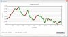
Results (assuming Bikely.com is reporting things correctly):
Elevations to work:
Elevations from work:
Regards,
Elephants
Having no GPS device and tight pockets I've been looking a way to generate my own elevation profiles for free
. I've found many sites that attempt to do this by getting you to mark out your route in Google Maps. The one I like the best is www.Bikely.com.So, to echo burncycle (Pro Connect First Range Test 2)...
Conditions:
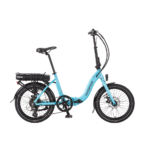
- Wisper 905SE City S
- No modifications
- Male rider (not that fit)
- 5' 9" tall
- 13 stone 2lbs
- Panniers with tools, waterproofs and my lunch (I'll assume it weighs 10lbs like burncycle's)
- Total weight 194lbs
- Bike in pedelec mode all the way, no throttle, no 'off-road' (deristricted) mode
- Entire journey done on a single battery charge
- Slight variations in the route to/from work due to the one-way system in Ross-on-Wye
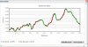
Results (assuming Bikely.com is reporting things correctly
):- 32 miles to work and back including 2762ft of ascents (from experience I know the bike will do a further 10 miles on top of this before it starts cutting out on hills)
Elevations to work:
Elevations from work:
Regards,
Elephants