Walkies!

Footie

Esteemed Pedelecer
Jun 16, 2007
549
10
Cornwall. PL27
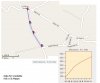
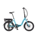
Testing the new battery today resulted in me cycling around the back lanes here in sunny North Cornwall :D
Unfortunately, the hills on these roads can be very steep. I found the first hill I could not cycle up - even standing up - so it was walkies for me.
This probably won't every effect most users but I had a devil of a job to keep up with the bike using the motor power to get the bike up the hill.
4 mph doesn't sound a lot - but up hill it can be a real challenge to keep up :eek:

LiFePo4 Test3 on Flickr - Photo Sharing!

Anyone else ever found it hard to keep up in this situation?
.
 

Tiberius

Esteemed Pedelecer
Nov 9, 2007
919
1
Somerset
Do you know exactly how steep?

I've never actually had to get off and push the Torq yet, but only because I only go near the really nasty hills with a full battery and when I'm feeling on form myself.

The last bit up to my house is 12% with a 16% peak, but its fairly short.

Nick
 

Footie

Esteemed Pedelecer
Jun 16, 2007
549
10
Cornwall. PL27
Do you know exactly how steep?
Not sure about the maths, but here goes.
Using an Ordnance survey map.
I estimate the hill is 1 km long and rises from 18 ft to 117 ft giving 99ft rise.
I calculate that .... 1 km = 3280ft .... So, 3280 divided by 99 will give the percentage?
It works out at 33% - is that right?
.
 

Tiberius

Esteemed Pedelecer
Nov 9, 2007
919
1
Somerset
No,

99 rise in 3280 along is a slope of 99/3280 * 100 % which works out as 3 %.
That can't be right, it must be a bigger rise than that.

On the other hand 33% is like climbing stairs.

Nick
 

musicbooks

Esteemed Pedelecer
Oct 10, 2007
719
29
No,

99 rise in 3280 along is a slope of 99/3280 * 100 % which works out as 3 %.
That can't be right, it must be a bigger rise than that.

On the other hand 33% is like climbing stairs.

Nick
The Agattu would cope with that no probs!
 

JamesC

Esteemed Pedelecer
Sep 1, 2007
435
5
Peterborough, UK
Not sure about the maths, but here goes.
Using an Ordnance survey map.
I estimate the hill is 1 km long and rises from 18 ft to 117 ft giving 99ft rise.
I calculate that .... 1 km = 3280ft .... So, 3280 divided by 99 will give the percentage?
It works out at 33% - is that right?
.
Is it an old OS map in imperial, or could the rise be 18 metres to 117 metres in 1km ?

This would give 99 / 1000 * 100 to make it % = 9.9 %

James
 

Footie

Esteemed Pedelecer
Jun 16, 2007
549
10
Cornwall. PL27
Is it an old OS map in imperial, or could the rise be 18 metres to 117 metres in 1km ?

This would give 99 / 1000 * 100 to make it % = 9.9 %

James
I think your right James - got my measurements mixed up.
I got the map from ordnancesurvey.co.uk - it says 1988 copyright, so got to be metric not imperial :eek:

Get-a-map online free from Ordnance Survey, Britain's national mapping agency

In my defence, I've been using an old imperial map all day (had it for years, to tight to buy a new one), which is why I mixed it all up.
.
 
Last edited:

Tiberius

Esteemed Pedelecer
Nov 9, 2007
919
1
Somerset
That looks like 270 feet in 0.5 mile, which is almost exactly 10%.

Just had a play with Sanoodi, and the problem is that at close in scales, it doesn't have the elevation detail needed. So it will give a broad average for a hill, which will hide the fact that there are steeper sections within it.

Here is one near me: Sanoodi

It looks like one section is up to 13%, but believe me, there's a very steep bit hidden in that. I only tried it in that direction once.

Nick
 
Last edited:

flecc

Member
Oct 25, 2006
53,412
30,745
It's still a real problem in Sanoodi, and many close marker points don't work to correct that since they don't cross enough elevation between pairs to be accurate

I've got one hill of 16% overall in which Sanoodi hides a near impossible 30% section.
.